Strong winds and heavy snow to parts of British Columbia

November 22, 2024

Today through Saturday. strong winds are expected along coastal British Columbia and Vancouver Island.


Depending on the location, winds will gust between 70 and 110 km/h. Power outages are possible and some minor wind damage could occur.


Some snow is expected as well. Today 10 cm is expected in Chilcotin. The Coquihalla Summit from Hope to Merritt could see near 15 cm, while 30 to 40 cm is expected Today into Sunday on Highway 3 from Paulson Summit to Kootenay Pass.


Alberta and Saskatchewan to see Heavy Snow

November 22, 2024

An area of low pressure will being heavy amounts of snow to portions of Alberta and Saskatchewan.


Snow will begin in southern Alberta this morning and will spread northward through the day. Some locations could see 15-25 cm of snow by Saturday evening.


Snowfall with total amounts of 10 to 20 cm is expected across southern Saskatchewan on Saturday.


The snow will end on Sunday morning for most areas.


Powerful Bomb Cyclone causing power outages in BC

November 20, 2024

A bomb cyclone is causing havoc from British Columbia to California.


Heavy rain and strong winds are expected. For East Vancouver Island, Sunshine Coast, Greater Victoria, and Southern Gulf Islands, gusts to 90 km/h are expected this morning. Across North and West Vancouver Island, gusts may reach 110 km/h.


These winds have already produced numerous power outages and reports of tree damage. There are thousands of customers in British Columbia who are without power. Most of the outages are in Northern and Southern Vancouver Island and the Lower Mainland / Sunshine Coast area.


Coastal sections of Vancouver Island, Sunshine Coast, Southern Gulf Islands and Metro Vancouver, and southern sections of Howe Sound near Bowen Island will see elevated ocean water levels accompanied by significant wind and waves are expected today.


System to bring winter weather to eastern Prairies

November 18, 2024

Some winter weather is on the way to the eastern Prairies on Tuesday.


An area of low pressure approaching from the western United States will bring rain, snow, and freezing rain to eastern areas of Saskatchewan this afternoon and overnight.


On Tuesday and Wednesday, eastern Saskatchewan and Manitoba will see snow. As the low moves north it will bring warmer air with it. As a result, the precipitation across Manitoba will likely start as rain or freezing rain.


Colder air will quickly regain control on Tuesday and change the rain to heavy snow.


On Tuesday, gusty winds will also develop.


Across eastern Saskatchewan and western Manitoba, snowfall accumulations of 15 to 30 cm are likely.


Above normal temperatures to persist across eastern Canada

November 13, 2024

Photo: Pexels/George Becker

Across the eastern half of the country, temperatures are expected to remain above normal for the second half of November.

Areas from Ontario to Newfoundland have seen temperatures well above seasonal in recent weeks including some areas above 20 degrees, mostly in Ontario and Quebec, while temperatures have cooled in many areas, above normal temperatures are expected to persist.

Below are the normal high temperatures for November 13:
  • St. John's 7°C
  • Halifax 7°C
  • Quebec 3°C
  • Montreal 5°C
  • Ottawa 5°C
  • Toronto 7°C
  • Thunder Bay 2°C


Stormy weather to impact Newfoundland

November 8, 2024

The weather might be nice across Newfoundland today, but that will change tonight and Saturday as an area of low pressure currently over northern Quebec will push across the Island portion of the province and bring snow, rain, and strong winds.
There is a special weather statement in effect for:
Avalon Peninsula North
Avalon Peninsula Southeast
Avalon Peninsula Southwest
Bay of Exploits
Bonavista North
Bonavista Peninsula
Buchans and the interior
Clarenville and vicinity
Deer Lake - Humber Valley
Gander and vicinity
Grand Falls-Windsor and vicinity
Green Bay - White Bay
Gros Morne
St. John's and vicinity
Terra Nova
For the Avalon, the potential exists for the first accumulating snowfall of the season, especially inland and over higher terrain. However, coastal areas may receive only rain.
Parts of northeastern and eastern Newfoundland could see the first accumulating snowfall of the season, especially inland and over higher terrain. However, parts of the coast may receive only rain.
For Green Bay - White Bay, Buchans and the Interior, Deer Lake and vicinity, and Gros Morne, precipitation may fall mainly as rain along parts of the coast. There exists considerable uncertainty with regards to the timing and accumulations associated with this system. Any change in the storm's track would significantly affect where and when the heaviest snow will fall.
 

Don't forget to turn your clocks back

November 1, 2024

For most of Canada, Daylight Saving Time ends tonight. At 2:00 a.m. clocks turn back by one hour.

Its also a good practice to change and testing the batteries in smoke alarms and carbon monoxide detectors.

When the clocks go back, we gain an hour of sleep. The sun will also set an hour earlier.
 

Your Halloween Forecast

October 30, 2024

When it comes to Halloween in Canada, it's not uncommon to see snow and cold temperatures. Just like when it comes to selecting a costume, planning for the weather is essential.

Rain will fall across most of Newfoundland, Quebec and Ontario. It'll be clear across the Prairies and some sporadic precipitation in British Columbia.

It will be quite warm across the eastern half of Canada with temperatures near 20 in some areas. It will be more seasonal across the west.
 

UN issues grim report on Climate Change progress

October 24, 2024

Photo by Pixabay: https://www.pexels.com/photo/photo-of-an-industrial-factory-emitting-smoke-247763/

The United Nations released the Emissions Gap Report 2023 on Thursday.

The report states that the world is heading for a temperature rise far above the Paris Agreement goals unless countries deliver more than they have promised.

On the current path and without action, the world could warm by 3.1°C this century. This would result in more increases in extreme weather events.

The predicted 2030 greenhouse gas emissions still must fall by 28 per cent for the Paris Agreement 2°C pathway and 42 per cent for the 1.5°C pathway.

Governments around the world have failed to cut emissions.
 

Heavy rain and strong winds expected in Newfoundland

October 23, 2024


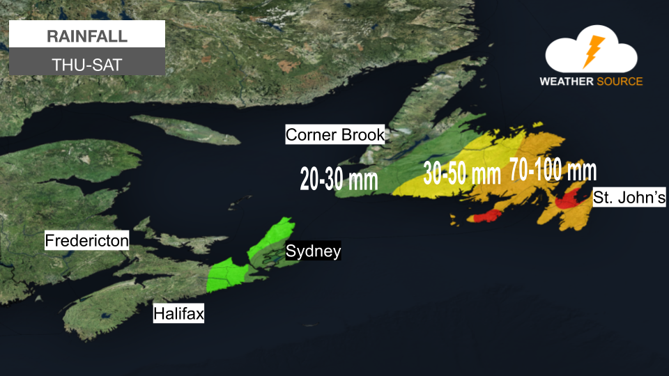
An area of low pressure off the east coast of the United States will move northward and bring heavy rain and strong winds to portions of Newfoundland and Nova Scotia.


The Avalon, Burin, and Connaigre Peninsulas will see the heaviest rain. Amounts of 70 to 110 mm of rain is possible from Thursday night to Saturday morning. Additionally, wind gusts between 70 and 80 km/h are expected.


Rainfall amounts of 40 to 70 mm is expected for east and northeast Newfoundland, from Bay of Exploits to Clarenville. Wind gusts between 70 and 80 km/h are expected.


On Thursday night and Friday morning eastern areas of Cape Breton Island will see up to 20 mm of rain.

 
Simple Footer